Japan from Above

On March 11, 2011, at 2:46 p.m. local time (05:46 UTC), a magnitude 8.9 earthquake struck off the east coast of Japan. The epicenter was 80 miles (130 kilometers) east of Sendai, and 231 miles (373 km) northeast of Tokyo. If initial measurements are confirmed, it will be the world’s fifth largest earthquake since 1900 and the worst in Japan's history.
This image of Japan from 1999 was taken as part of SeaWiFS, the Sea-viewing Wide Field-of-view Sensor Project.
Japan Earthquake Seismograph

The magnitude 8.9 earthquake east of Honshu on March 11, 2011, as recorded on a SEIS-UK seismometer in the University of Leicester’s Department of Geology. The three traces measure movement of the Earth's surface in the vertical, north-south and east-west direction. SEIS-UK is part of the Natural Environment Research Council’s Geophysical Equipment Facility.
Tsunami News

Tsunami strikes Japan's coast, March 11, 2011.
Traveling Tsunami
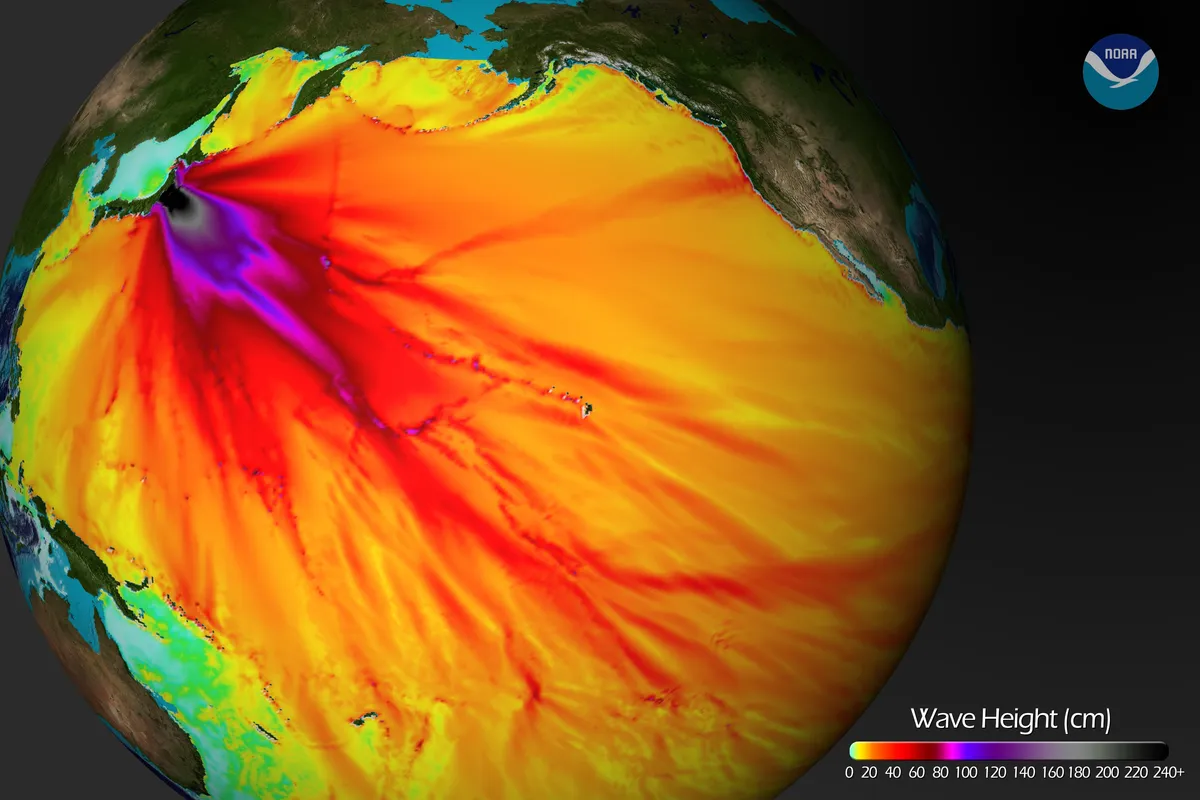
The 8.9-magnitude (which may have been upgraded to a 9.0) earthquake that struck Japan triggered tsunamis across the region. Here, results from a computer model run by the Center for Tsunami Research at the NOAA Pacific Marine Environmental Laboratory show the expected wave heights of the tsunami as it travels across the Pacific basin.
The largest wave heights are expected near the earthquake epicenter, off the coast of Sendai, Honshu, Japan. The wave will decrease in height as it travels across the deep Pacific but grow taller as it nears coastal areas. In general, as the energy of the wave decreases with distance, the near-shore heights will also decrease. For example, coastal Hawaii will not expect heights of that encountered in coastal Japan, according to NOAA.
Coastal Flooding

NASA's Terra satellite’s first view of northeastern Japan in the wake of a devastating earthquake and tsunami reveal extensive flooding along the coast. Water is black or dark blue; the shore is outlined in green, showing higher-elevation land that is above water, likely preventing the flooded water from returning to the sea.
Pacific Depth

The image shows the depth of the Pacific Ocean floor. Notice the similarity between areas of low wave height and deeper areas of the ocean.
Japan Shakes

This map shows the location of the March 11 earthquake, as well as the foreshocks (dotted lines), including a 7.2-magnitude event on March 9, and aftershocks (solid lines). The size of each circle represents the magnitude of the associated quake or shock. The map also includes land elevation data from NASA's Shuttle Radar Topography Mission and ocean bathymetry data from the British Oceanographic Data Center.
According to the U.S. Geological Survey (USGS), the earthquake occurred at a depth of 15.2 miles (24.4 km) beneath the seafloor.
Enormous Whirlpool

Whirlpool created by the earthquake off the coast of Japan, March 11, 2011.
tsunami hazard sign

The 8.9-magnitude earthquake and tsunamis off the coast of Japan were expected to send large waves along the coast of San Francisco, here at Ocean Beach.
Santa Cruz Waves

Water receding on the beaches of Santa Cruz, Calif., on March 11, 2001, just after the earthquake and tsunami struck Japan.
Miyagi Fires

In the aftermath of the massive earthquake that struck northeastern Japan at 2:46 p.m. local time on March 11, 2011, and its subsequent tsunami, several oil refineries and industrial complexes caught fire, including facilities in the Port of Sendai and a petrochemical facility in Shiogama, where a large explosion has been reported. This pair of images, acquired on March 12, 2011 by the Multi-angle Imaging SpectroRadiometer (MISR) instrument aboard NASA's Terra spacecraft, shows a large smoke plume that appears to be associated either with the Shiogama incident or the Sendai port fires. The presence of clouds makes it difficult to pinpoint the exact origin. The data were obtained at a local time of about 10:30 a.m.