Earthquake with magnitude of 2.6 recorded off Cork coast
AN earthquake measuring 2.6 magnitude occurred off the coast of Cork, Ireland, at 7.57am today.
It is the first recording of seismic activity in the region since records began.
The INSN, which monitors seismic activity in the region, said the earthquake is the first known seismic event of its kind to be recorded in the region since Irish records began in 1978.
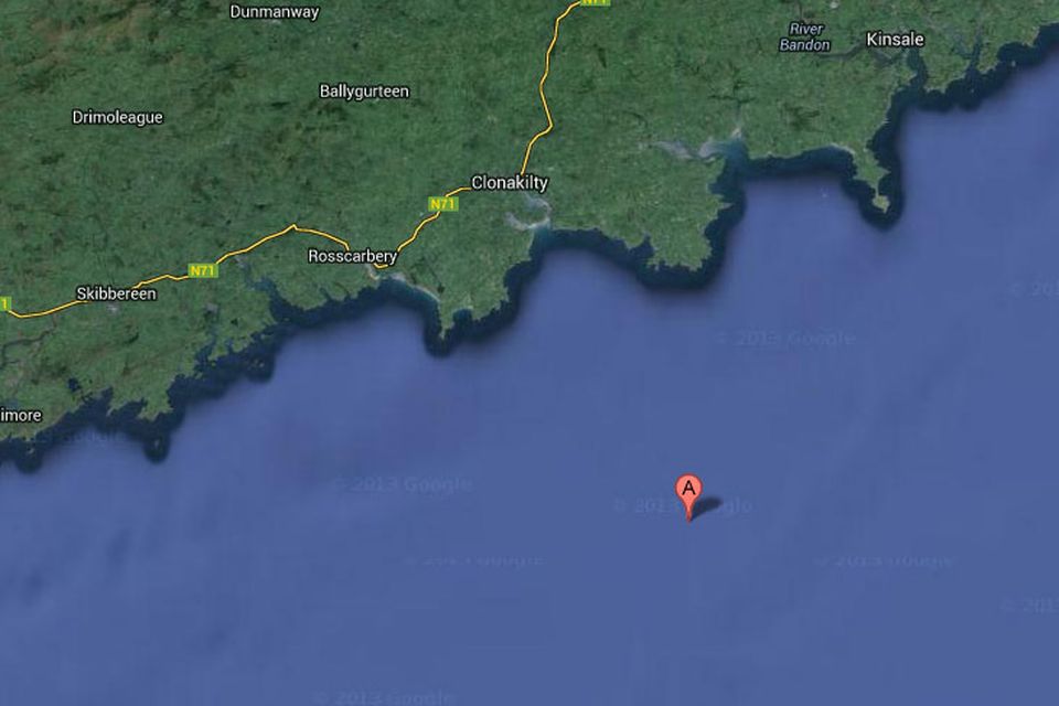
The quake occurred in the Celtic Sea approximately 18km south of Ballymacshoneen on the Seven Heads Peninsula in West Cork, and was recorded by INSN seismic stations in Valentia (Kerry), Dublin and Wexford and British Geological Survey stations throughout Wales.
“This occurred in a region that has not previously shown any seismic activity since we started recording activity 35 years ago," Said INSN Director Tom Blake from Dublin Institute for Advanced Studies (DIAS). "We have received felt reports from Courtmacsherry and Timoleague, which are located 25 and 27 kilometres respectively away from the epicentre.”
The strongest earthquake recorded in Ireland in recent years took place on June 6th 2012 when a magnitude 4.0 earthquake was recorded 60km west of Aughleam, Belmullet, County Mayo.
The most significant land earthquake to be recorded in Ireland in recent years occurred when a 2.7 magnitude quake hit Lisdoonvarna in County Clare in May 2010. It also was the first earthquake to be recorded in the west of Ireland in modern times.
Join the Irish Independent WhatsApp channel
Stay up to date with all the latest news