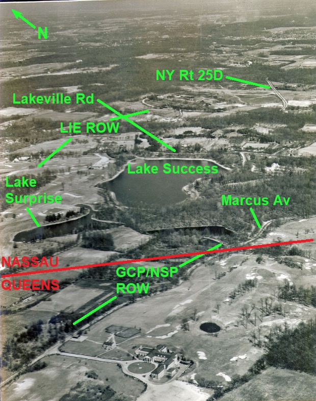
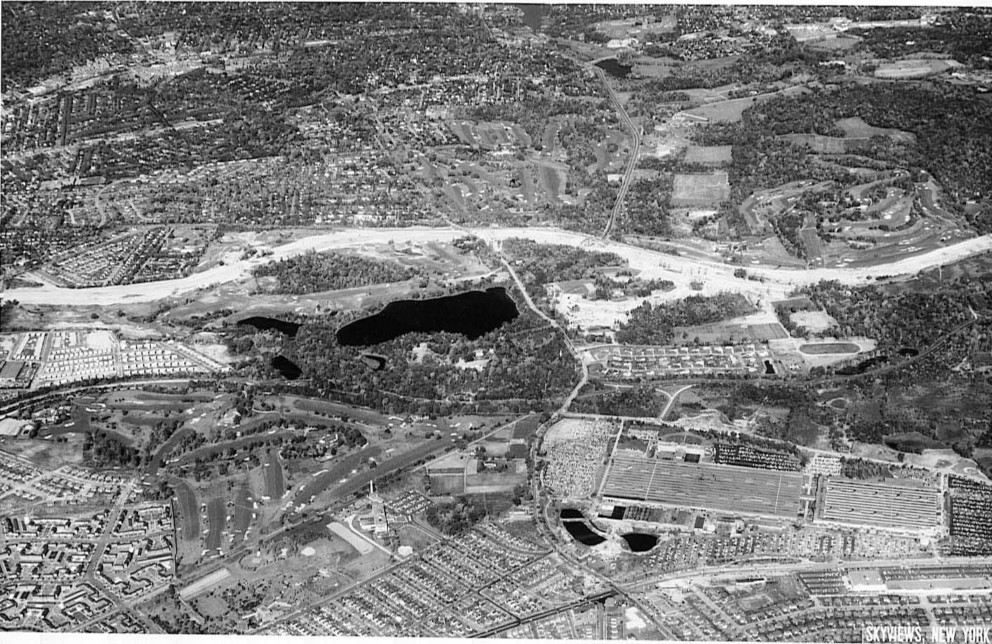
Mystery Foto #41 Solved: An Aerial of Glen Oaks and Lake Success Taken in 1929

This weekend's Mystery Foto was associated with the William K. Vanderbilt Jr., the Long Island Motor Parkway and the Vanderbilt Cup Races.
Mystery Foto questions:
- Identify the location and orientation of the aerial
The aerial, courtesy of the Suffolk County Vanderbilt Museum, was taken over Glen Oaks, Queens and Lake Success looking east and north.
- Identify the key roads and buildings in the Mystery Foto
Major roads
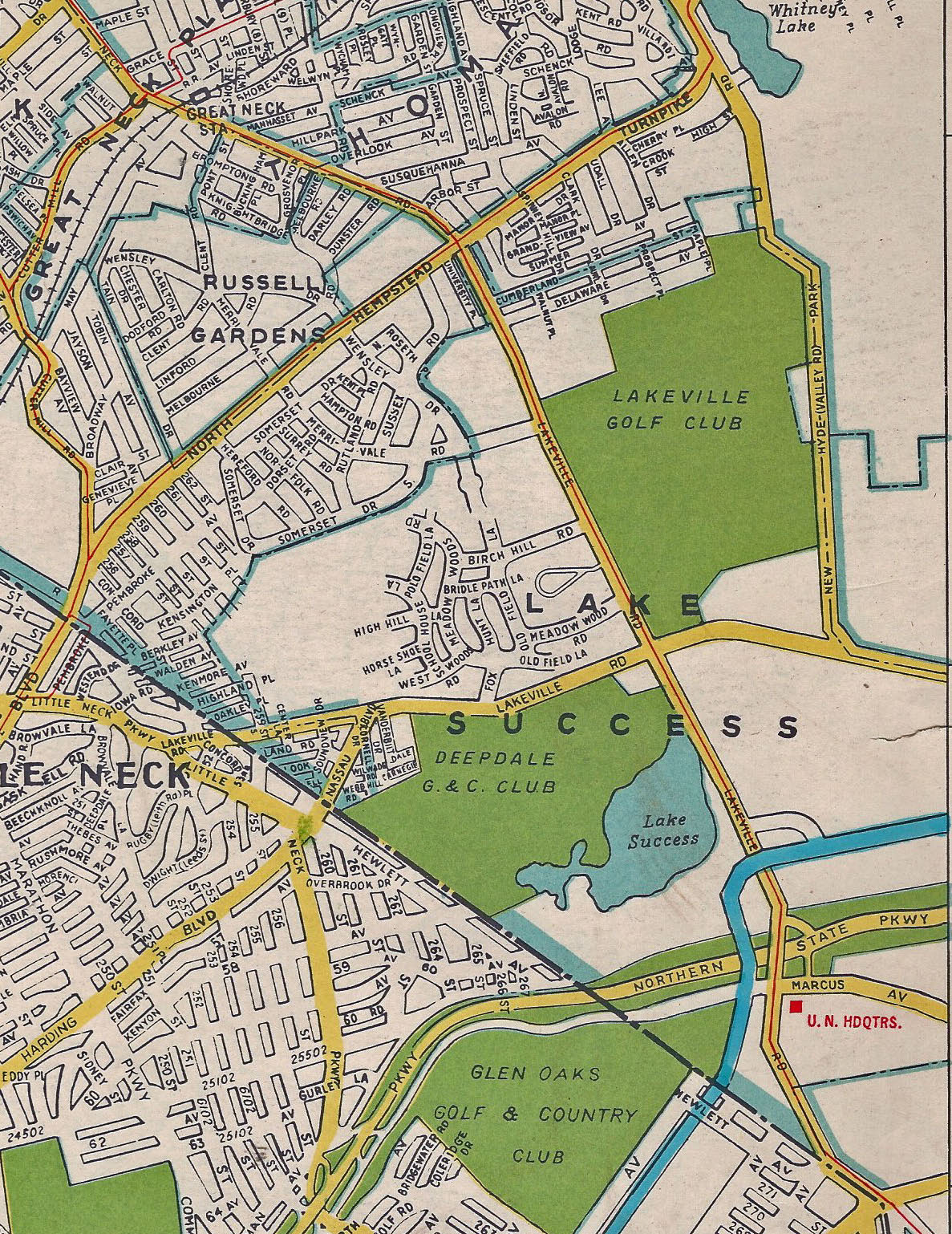
-Lakeville Road north above the lake
-The Long Island Motor Parkway crossing Lakeville Road (middle right of the aerial)
-Marcus Avenue diagonally across the aerial
-I.U. Willets Road (barely visible, middle left above Lakeville Road)
Buildings
-Glen Oaks Golf & Country Club Clubhouse (middle bottom of aerial)
-Deepdale Mansion- former home of William K. Vanderbilt Jr, (while building to the south of the lake)
-The Deepdale Golf Club clubhouse (middle left, north of the lake)
-Great Neck Lodge (left of Motor Parkway after the Laeville Avenue Motor Parkway Bridge)
- Identify the golf course(s)
-Glen Oaks Golf & Country Club (bottom right corner of the aerial). Now North Shore Towers Country Club.
-Deepdale Golf Club (middle left of the aerial, north of the lake). Now Village Club at Lake Success.
- Identify the lakes
Lake Success and Lake Surprise (the smaller lake west of Lake Success)
- Link the aerial to the Long Island Motor Parkway
The Motor Parkway can be seen crossing Lakeville Road (middle right of the aerial)
- Link the aerial to the Vanderbilt Cup Races
1905 and 1906 Vanderbilt Cup Race courses included I.U. Willets Road and Lakeville Road
- Link the aerial to William K. Vanderbilt, Jr.
-Deepdale Mansion was the summer home of William K. Vanderbilt , Jr. from 1902 to 1910. He continued to own property surrounding Lake Success.
-In 1924, Vanderbilt converted some of his property north of the lake into a private golf course. On October 26, 1924, the Deepdale Golf Club was incorporated.
- What is the year of the aerial?
1929 before the Northern State Parkway and Long Island Expressway were built in this section of Lake Success.
Comments (11)
Congrats to Joe Osterle, Greg O. David I., Art Kleiner, Sam Berliner III, Tim Ivers, Brian McCarthy, Frank Femenias, and Frank Mendyk for correctly identifying the location.
Kudos to Brian McCarthy, Frank Femenias and Frank Mendyk for correctly identifying the two golf courses in the Mystery Foto.
Enjoy,
Howard Kroplick
Update: Femenias' Findings (Submitted by Frank Femenias)
Sam's divided highway.
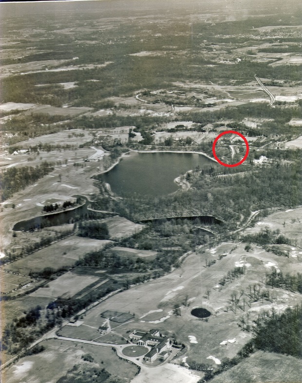
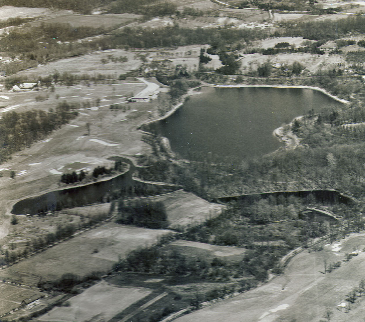
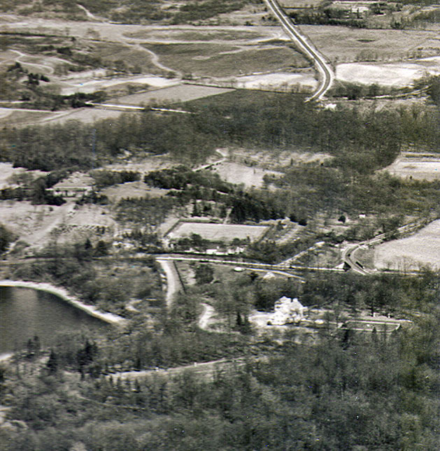
Close-Ups
Deepdale Golf Club is north (left) of the lake. Lakeville Road is east of the lake.
The Long Island Motor Parkway can be seen in the middle right.
The white building west of Lakeville Road is the Deepdale Mansion. Although reduced in size, it is still standing today.
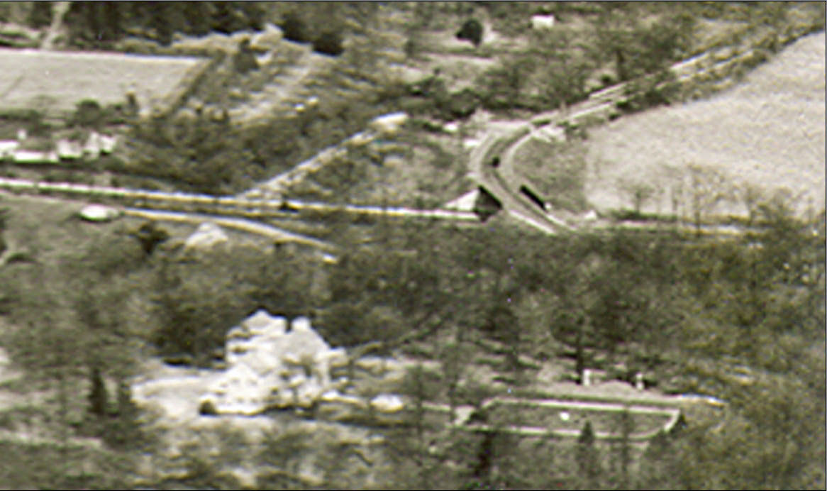
The Lakeville Avenue Motor Parkway Bridge, the Great Neck Lodge and the Deepdale Mansion.
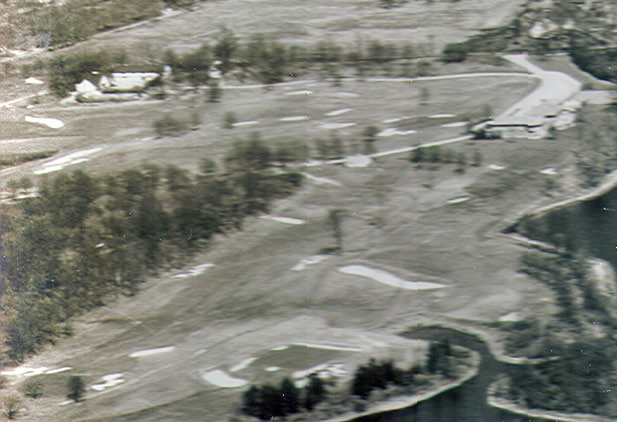
The Deepdale Country Club and its clubhouse.
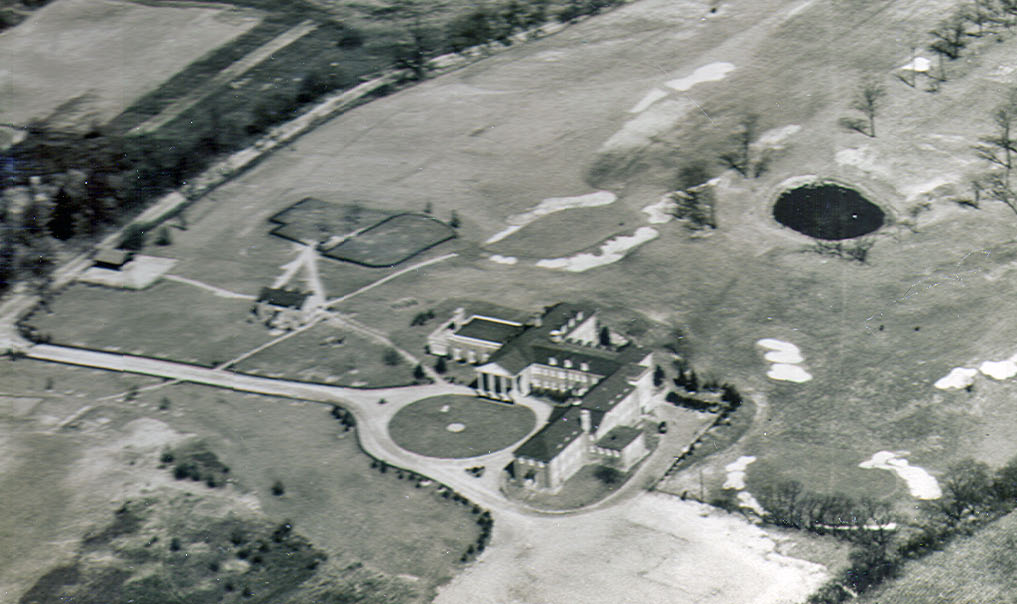
The huge clubhouse for the Glen Oaks Golf & Country Club.
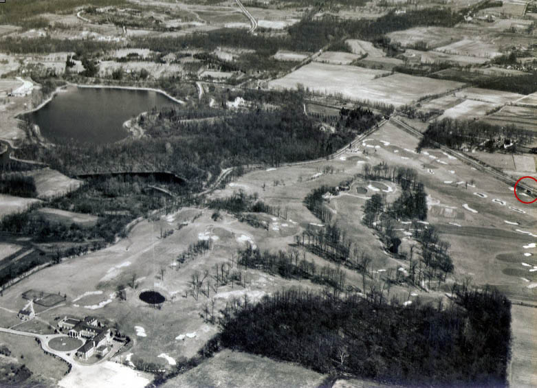
An expanded view of the aerial.The Vanderbilt Farmway Bridge can be seen on the far right.
1938 Map
1926 Aerial
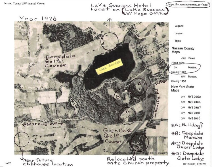
Submitted by Brian McCarthy. Brian's source: Maps and aerials found on MyNassauProperty.com
How to find a Nassau County aerial on this website:
Once on the site, locate the area that you wish to focus on. Keep zooming on the area until the aerials appear. Click on layers and select the aerial year.
Note: Sometimes you will need to restart the process when switching aerial years.
1956 Aerials of Lake Success
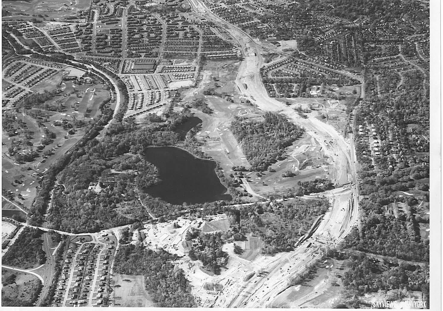
The Long Island Expressway can be seen under construction right through the Deepdale Golf Club.
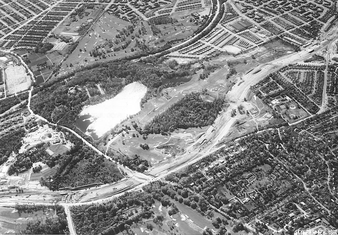
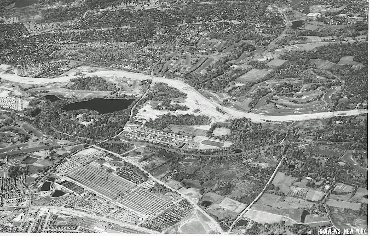
2017 Aerial
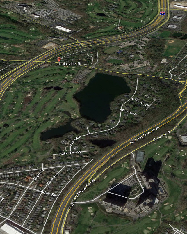
A "Today" View of the Mystery Foto. The North Shore Towers complex is in the right corner.


Comments
Lake Success. Pix is looking East and slightly North. Two thirds up the right side we see the LIMP sneak into the picture as it bends across the Lakeville Road steel bridge. The Great Neck Lodge is very blurry, but it is just to the left of the LIMP as it finishes it’s bend eastward. Willie K’s house is seen just below it. The VCR used Lakeville Road, however the race did not wander this far south, instead connecting towards the westward end of IU Willets Road. As for the year, well…. it is before the northern parkway or GCP in this area, and before the Deepdale Estate was destroyed.
Identify the location and orientation of the aerial
-Lake Success looking Northeast
Identify the key buildings in the Mystery Foto
-Deepdale mansion, Great Neck Lodge
Identify the golf course(s)
-Lake Success Golf Club
Identify the lakes
_Lake Success
Link the aerial to the Long Island Motor Parkway
-The Motor Parkway and Great Neck Lodge can be seen just along the right edge of the photo
Link the aerial to the Vanderbilt Cup Races
-1905 & 1906 races utilized part of Lakeville Road (just beyond the lake) for the course.
Link the aerial to William K. Vanderbilt, Jr.
-His mansion Deepdale can be seen to the right of the lake along the right edge of the photo.
What is the year of the aerial?
-1929
Well I don’t know most of the answers but I believe we’re looking northeast at Lake Success. To it’s right, in the pic, is the Deepdale mansion (bright white blob). Immediately centered above the mansion is the entrance to the Great Neck lodge off Lakeville Road. To the right of that, if enlarged, can clearly be seen the elusive LIMP bridge over Lakeville Road. Looks like an eastbound car on LIMP just curving toward the lodge OR possibly (??) the shadow of the kiosk there?
I believe the road running diagonally from the lower left corner up off the right side must be the current day Marcus Ave. Below that the Glen Oaks
Country club/golf course. I’ve got no guess on the date.
Addendum to my last “I’ve got no guess on the date” comment except that there’s no hint of the start of the NSP (which would be just above Marcus Av) so very early 1930’s or before.
Lake Success looking northeast.
Golf course is the Glen Oaks Country Club with its prominent clubhouse shown. Other buildings are Willie K’s Deepdale estate. Lakeville road. Deepdale Golf Course.
Used as part of the 1905 Cup Race.
Motor Parkway ran along Glen Oaks property.
1929 photo.
Far too many questions for my feeble brain. It’s almost certainly Lake Success looking ENE from over today’s Douglaston GC. If you think I can find my references to the two smaller lakes, whose names are right at the tip of my tongue, fuhgedaboudit! The then-new NSP, 15 Jul. 1933, runs off into the distance at upper right and Marcus Avenue runs E-W across the lower right corner, bordering the Glen Oaks G&CC;. Lakeville Road bisects the image horizontally (N-S). The white blob at upper right just below (W of) Lakeville Road is Willie K’s house. The large cluster of buildings at bottom center is the Glen Oaks clubhouse. ‘Nuf! Sam, III
Whoops! Missed a tiny smitch of the LIMP at far right immediately above (E of) Lakeville Road. Sam, III
Looking east at Lake Success about 1928.
Glen Oaks Golf course and clubhouse at bottom.
LIMP running diagonally past clubhouse lower left to top.
Vanderbilt’s Deepdale estate at top right.
My favorite Mysterys, Aerials!
*Location/Orientation of Aerial: Bird’s Eyeview of Glen Oaks ( Queens ), & Lake Success ( Nassau ).
*Key Rds./Buildings: Small section of the LIMP, Lakeville Rd., and Marcus Ave. Lake Success Hotel on N/S of lake. Deepdale Mansion on S/S of lake. Excellant view of Glen Oaks Clubhouse, south of Marcus Ave.
*Golf Courses: Deepdale and Glen Oaks.
*Lakes: Lake Success
*Aerial’s relation to LIMP: Parkway is evident 1/3 down on right ( Heading west and south over Lakeville Rd ).
*Aerial’s relation to VCR’s: Lakeville Rd was part of the 1906 race.
*Aerial’s relation to W.K.V. Jr.: LIMP, Deepdale Golf Course and Mansion.
Aerial’s year: No Northern State Pkwy and LIE. I’ll guess 1930.
Lake Success looking NNE, with Queens/Nassau County line slightly diagonal at center of photo. Willie K’s Deepdale Estate at bottom center. Today, Robert Moses’ GCP/NSP runs along right side of the lake and cuts through the estate, also location of today’s North Shore Towers. LIE today on left side of lake. Lakeville Road above the lake, and a smidgen of Motor Pkwy on center right side of photo, curving over Lakeville Road heading East, once location of the Motor Parkway’s Western Terminus in 1911. North Shore Towers Country Golf Club (Glen Oaks Country Club) on the right side, Lake Success Golf Club (Deepdale Country Club) on the left. Willie K was President of the Motor Parkway and Vanderbilt Cup Races. Photo was taken between 1912-1931, after the LIMP’s extension west from Lakeville Rd, and before construction of the GCP in 1931. LIE construction did not appear here until 1954-58
The photo is taken over Glen Oaks looking towards the northeast and looking at Lake Success.
The main roads in the photo are Lakeville Rd, I.U. Willets Rd, New State Rd (old NY25D ), and the LIMP.
You can observe Willie K’s Deepdale Mansion , the Great Neck Lodge and the Glen Oaks hotel.
The 2 golf courses are Deepdale and Glen Oaks.
The Lake is Lake Success
The LIMP is in the right hand corner with the Lakeville RD bridge and the Great Neck Lodge.
The 1905 and 1906 Vanderbilt Cup races were held on Lakeville Rd and I.U. Willets Rd.
Willie K’s Deepdale mansion is seen in the photo and the golf courses were constructed on his property. He started the Deepdale club in 1924.
I would say the photo was taken around 1927- 1930.
Lake Success - of course! Wasn’t the third one Little Lake Success (that just came back to me) - anyone? Now, I have a real problem with 1929 date. Moses only announced the beginning of construction of NSP in Mar 1931! The divided highway in the distance can only be the NSP, so 1929 just doesn’t fly. Worse yet, funding for that segment (Lakeville to Willis) wasn’t even approved until 1932 and it didn’t open until 15 Jul 1933, so 1932 is the earliest possible year. Spoilsport Sam (III)
————————————————-
Howard Kroplick I
Sam III, the 1929 date was captioned on the reverse side of the original aerial. I don’t believe the road in the foreground is the Northern State Parkway. I thought it may be I.U. Willets Road.
Howard….Did the Lake Success Hotel and Cottage ( Blog Date 8/27/2012 ) eventually become the Deepdale Golf Club? And then Village Club at Lake Success/Lake Success Village Office.
___________________________
Howard Kroplick:
Brian, excellent question! Will need further research.
Howard, the “expanded view of the aerial” that you added with Monday nights reveal showing the Vanderbilt Farmways bridge, also shows the northwest bulkhead/retaining wall (bright white) of the Smith Farmways bridge. I believe what seems to appear as a triangular patch of trees immediately to the south (pic right) of LIMP there, is really just a narrow north-south strip of trees on either side of the Smith road basically on the ramp/grade from it?? Also possibly the Smith property line as I believe the oval field above it (orientated in this pic pointing roughly between 11 to 5 o’clock) is not Smith’s?? By-the-way, that field is completely grown over with trees (woods/forest) by the 1950’s.
I meant Lake Surprise, not Success. As to the dating, I refer to the dual highway at right center, not in the foreground. If it’s not NSP, then what is it? Was Marcus once divided between Lakeville and NHP Road? It wasn’t so in your 1955 aerial. Oh, my gosh; it IS now! Sorry ‘bout that. Marcus it is and ‘29 it may well be. Sam, III
David, I agree with the triangular tree patch but my thoughts on Smith bridge was always focused on those two open planting patches, north and south of the LIMP. He needed the bridge to connect. To me, 11 o’clock seems not related to Smith but 3 to 9 is. Perhaps I’m reading your msg wrong. It seems the Smith bridge was situated along the east side of both his properties.
Brian, you’re in deep here.
The road in the upper portion of the photo is New State Road or the old NYS Route 25D. This road is on the right of way of the present LIE. The road was decommissioned when the LIE was built. The future ROW of the Northern State on the top of the photo can not be seen, it would be off the photo on the right. The correct date of the photo would be 1929 as stated.
Marcus Ave after Lakeville Rd can not be seen in the originally posted Mystery Foto. It is off to the right hand side. Marcus Ave can be seen in the expanded view photo which was later posted. The road displayed on the photo is a single lane road and not a divided highway. You can refer back to the 1939 Dolph and Stewart map and the 1927 E. Belcher Hyde map. I.U Willets Rd can be observed branching off to right at a wye just as Rt. 25D starts.
O. K.; I give up! Marcus is divided at lower right but WHAT is the divided highway below (west of) the broad belt of trees at near-upper right (2/3 to 3/4 of the way up), starting at a large white rectangle on the right margin, please? Sam, III
Great stuff Brian! How did you find that1926? More tools and investigation on the way….
______________________________________________________________________
Howard Kroplick:
Frank, I asked Brian the same question. Here is his replay:
Brian: Go to https://lrv.nassaucountyny.gov/map/ Once your on the site, click Land Record Viewer; then click maps. Then it’s just a matter of zooming into an area. The site has 1926,1950 and current maps to view.
Howard This is a wonderful resource to obtain 1926 and 1950 aerials of any location in Nassau County.. Remember to keep zooming into the location until the aerial appears. If you change the view from 1926 to 1950, sometimes you need to start the process from the beginning.
C’mon, people! I don’t mind be(com)ing suoer-annuated but I’ve had maps galore posted for many years. The applicable 1943 topo is at <http://sbiii.com/limpmaps/seclf14r.gif>, on my LIMP Maps page 1, <http://sbiii.com/limpmap1.html>, and see also the preceding page, <http://sbiii.com/limpmaps.html>, as well. The comparative 1926, 1950, and 2000 aerial views across all Nassau, from the 2004 Bond Act project, were SUPPOSED to have been posted on my site but I can’t find them; I have the pix and, if necessary, will recreate the page with all of them. The Bond Act background, with maps, is at <http://sbiii.com/limpncpk.html> and <http://sbiii.com/limpnaer.html>; the latter is the same as the former, having apparently overwritten the latter, which should have had the aerial strips. I’ve got some work to do. Stay tuned. Sam, III
Yee-hah! I found an old copy of the Nassau County aerials page and restored it: <http://sbiii.com/limpnaer.html>. The full 1926, 1950, and 2000 strip aerials are there. Also, I commend to you the full set of annotated 1942/43 topo maps:<http://sbiii.com/limpnass/4243nas1.gif> through <http://sbiii.com/limpnass/4243nas8.gif>, i.e. 4243nass1, 4243nass2, 4243nass3, 4243nass4, 4243nass5, 4243nass6, 4243nass7, and 4243nass8.gif. They run all the way across Nassau. For my next trick, I found the same topos with the LIMP RoW highlighted; <http://sbiii/limpmaps/HiLTopos/4243ns1h.gif> through <4243ns8h.gif>. <ns1h> applies to this thread. Not only those, but the full LIMP RoW - more to follow! Per ardua ad astra! Sam, III
Sam, great puzzle! If I’m correct on the divided hwy location, it’s today’s Lake Road branching off of Lakeville Rd., direct entrance to former Deepdale Estate, straight to the ‘big house.’ I think you’re onto something. Sending Howard attachments